Introduction
Introduction for the DRYRivERS mobile application
.png)
Many rivers worldwide stop flowing and/or dry out, with over 50% of the global river network including drying channels. This percentage is dramatically increasing because of the global climate change. Many streams and rivers that used to have flowing water all year round are now completely drying out during some periods or just maintaining disconnected pools in the riverbed. For example, in Mediterranean-climate streams, the duration of drying periods that typically occur in summer are becoming longer, while in areas with more humid and colder climate, rivers and streams are now experiencing these drying periods for the first time ever. Despite having information on river drying events is crucial for maintaining biodiversity, ecosystem functions and the provisioning of ecosystem services to humans, most drying river networks (DRNs) in Europe are not yet mapped.
The aim of the DRYRivERS app is to enable citizens to collect information about drying events. With this field information, citizens will contribute to the mapping of drying rivers and will help to improve scientific predictions of the future impacts of climate change in these ecosystems.
There are two "faces" of DRYRivERS:
- The mobile application was developed to be quick and easy to use. Its main purpose is to allow offline data recording on the field. Fore more info, please visit the How does it work page.
- The web application (https://www.dryver.eu/app) is a realtime map of all recorded data. The users here can add new spots and records, or they can edit their previously recorded data. There are several other features of the web application, for more info, please see the tutorial file.
You can help scientists by providing the following information
At each spot, where you would like to record the status of a watercourse, the app will ask you to the followings:
- Share the geolocation of the spot.
- Take a photo showing the hydrological conditions reported.
- Provide the hydrological conditions. You will need to report if in the river channel:
1. water is flowing (Figure 1),
2. water is present but not flowing and allocated in disconnected pools (Figure 2),
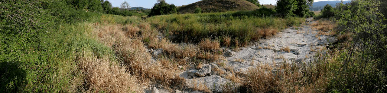
3. there is no water and the channel is completely dry (Figure 3).
The app already started mapping drying events in streams and rivers all around the World. You can see the existing records by visiting the project’s website at Citizen science\Data (https://www.dryver.eu/app). We hope that you will contribute too by providing data from drying streams and rivers!
We hope you will contribute too by providing data from rivers all around Europe!
. ©N.Cid.")
. ©N.Cid.")
. ©N.Cid. | Figure 2. River channel with disconnected pools. Matarraña River (Spain). ©N.Cid. | Figure 3. River channel completely dry. Albarine River (France). ©B. Launay.")
A short video about the application
Downloading and installing the application
The app can be downloaded from Google Play and App Store by searching for the app's name (DRYRivERS).
Contact information
For general issues and data related questions:
Amélie Truchy:
Post-doctoral researcher at Researcher at National Research Institute for Agriculture, Food and the Environment (INRAE).
citizenscience@dryver.eu
For technical problems:
Andor Tamás
dev@dryver.eu