Newsletter - July 2021
-
Overview of DRYvER, an interdisciplinary project focusing on drying river networks
DRYvER (Securing biodiversity, functional integrity and ecosystem services in DRYing riVER networks) is a research & innovation project focusing on drying rivers and the impact of climate change. The project is funded by the Horizon 2020 programme of the Europe Commission and brings together 25 partners from 16 countries in Europe and South America as well as from China and the USA. DRYvER was launched in September 2020 and will last for 4 years.

Why is DRYvER needed now?
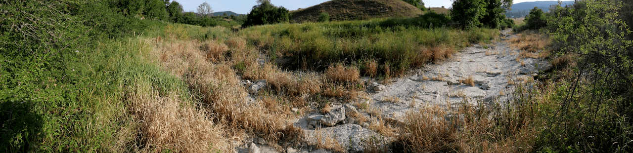
River networks are among the most threatened hot spots of biodiversity on Earth. They provide key ecosystem services which are essential to sustain human wellbeing (e.g. drinking water, climate regulation, food production…). But climate change and increased human water use are causing more rivers and streams to dry up worldwide, including in Europe: over 50% of the global river network include drying channels and this share is dramatically increasing worldwide. This trend is having devastating impacts on people and on the environment.
However, despite the critical role rivers play, drying river networks have received little attention from scientists and policy makers, and the public is not aware of their importance. As a result, there is no effective strategy for integrated biodiversity conservation or ecosystem management of drying river networks in the face of climate change.
The DRYvER project aims to address this gap. Working in collaboration with resource managers and citizens, we plan to co-develop new strategies to mitigate and adapt to the effects of climate change on drying river networks.
What is the objective of DRYvER?
.png)
.png)
DRYvER will collect, analyse and model data from nine drying river networks in Europe and South America.
The objective is to create a new global meta-system approach that incorporates hydrology, socioeconomics, ecology and biogeochemistry perspectives. DRYvER will investigate how biodiversity, ecosystem functions, ecosystem services and their values in drying river networks are directly and indirectly impacted by climate change.
The work performed in DRYvER will be helpful to design strategies, tools and recommendations for adaptive management of river networks. DRYvER will also provide knowledge-based strategies and tools for cost-effective adaptive management of drying river networks in Europe and worldwide.
.png)
-
DRYvER activities since September 2020: focus on data collection and launching the activities with citizens and stakeholders
A first phase of the project dedicated to data collection in nine river networks in Europe and South America
As initially planned (and in spite of Covid-19), data collection started at the beginning of 2021. The first field campaigns already took place in Spain, France, Czech Republic, Hungary, Croatia, Finland, as well as in Ecuador, Bolivia and Brazil. They focused on collecting data on microbes, macroinvertebrates and fish, and in some cases on biomass as well.
These campaigns took place in the pre-drying phase and will be followed by other data collection campaigns during the summer (drought) and autumn (post-drought conditions).
Mapping of drying river networks stakeholders
A first exercise was carried out by Fresh Thoughts and REVIVO, two DRYvER partners, to identify key stakeholders and players involved in the management of drying river networks in the six European river networks studied in the project as well as national and European level. A total of 48 stakeholders have been identified so far in the local river networks. A questionnaire as well as a series of interviews were organized to understand the stakeholders’ motivations in the management of river networks.
A first exercise was carried out by Fresh Thoughts and REVIVO, two DRYvER partners, to identify key stakeholders and players involved in the management of drying river networks in the six European river networks studied in the project as well as national and European level. A total of 48 stakeholders have been identified so far in the local river networks. A questionnaire as well as a series of interviews were organized to understand the stakeholders’ motivations in the management of river networks.
These stakeholders will be invited to participate to the next project activities, including co-creation workshops to design management strategies or the Stakeholder Committee to contribute to the dissemination of DRYvER results.
In DRYvER, we started by engaging with local stakeholders, but this network will be slowly enlarged to other stakeholders, including at national and European levels. If you are interested in this process, you can contact dryver@dryver.eu.
Citizen science
Building on previous efforts (SMIRES, NETLAKE, AMBER…), DRYvER puts a strong emphasis on citizen science activities. One of the objectives of the project is to create a citizen science network to monitor the drying events across Europe.
A smartphone application will be launched during summer 2021 to support this effort. It can be used by citizens in Europe to monitor water flows in river networks. This application is intended to be first used in the six European river networks studied in DRYvER and will be later extended to the whole Europe. The data collected will be used for hydrological modelling activities in the project, which will feed the DRYvER conceptual framework.
Núria Cid tells you more about this app and the citizen science efforts in DRYvER in an interview.

 Photos: B. Launay.
 -
Citizen Science App – Interview with Núria Cid

Could you briefly introduce yourself?
Núria Cid: I am a freshwater ecosystems researcher working on the applied metacommunity ecology of intermittent rivers to adapt ecosystem assessments to climate change. I have devoted most of my research to studying the implications of climate change for rivers bioassessment and conservation. I have participated in previous EU projects such as BioFresh “Biodiversity of Freshwater Ecosystems: Status, Trends, Pressures, and Conservation Priorities”, and recently coordinated the LIFE+ TRivers project, dedicated to improving the management of Mediterranean intermittent rivers and ephemeral streams. The past 2 years, I have contributed to transferring the metasystem theory into applied perspectives at INRAe Lyon, supported by a Make Our Planet Great Again grant.
Could you introduce the Citizen Science application in a few words?
NC: DRYRIVERS is an application to collect information about drying events in rivers. It is very simple and easy to use. It has three main features that allow to collect the basic information needed: (1) geolocation of the spot (2) the hydrological conditions of the river site (if the water is flowing, if water is present but not flowing, if the river is dry), and (3) a photo of the river site.
If there is no cell phone connection, there is an option to use the GPS of the cell phone to locate the site and enter the information. Then, once we have connection, we can upload the information registered.
For the moment, the app can be downloaded from Google Play Store from the six European DRYvER member countries (Croatia, Czech Republic, Hungary, Finland, France, Spain), and will be available to other countries soon. We also plan to translate it to different languages, and to make it available at the Apple Store.
What was your role in the development of the Citizen Science App?
NC: I have supervised the design and the information on the web, as well as the instructions. I am also responsible for engaging the local stakeholders in the usage of this application. In the coming months, Amélie Truchy (INRAE) will take over the activities related to the citizen science app, while I move to a permanent position in Spain.
What is the point of launching such an application in a project like DRYvER?
NC: Many rivers worldwide stop flowing and/or dry out, with over 50% of the global river network including drying channels. This percentage is dramatically increasing because of the global climate change. Many streams and rivers that used to have flowing water all year round are now completely drying out during some periods or just maintaining disconnected pools in the riverbed. However, most drying river networks in Europe are not yet mapped. Most official gauging stations are located in the main river watercourses, so we are missing information from many lower order rivers and streams. In addition, gauging stations only measure zero flow, but cannot measure if a river is completely dry or maintains water in disconnected pools. Citizens can contribute to fill this gap.
What role will citizens play in DRYvER by using the application?
NC: With the information provided by using the app, citizens will contribute to the mapping of drying rivers and thus help improving the accucary of hydrological projection of the future impacts of climate change in river networks. In DRYvER, this data will be used to calibrate hydrological models at each case study and raise awareness on the issue of drying river networks.
What is the expected impact of the application in the coming months?
NC: Now the app is still in the beta version. During the following months, we expect that local stakeholders within each case study test the app and start recording data.
How will you advertise the application?
NC: Once the final version of the app is ready, it will be advertised via the DRYvER website, social networks, local journals, and, taking advantage of international events such as the Word Rivers Day, organize local activities to promote the use of the app.
Will participants have access to the results via the application?
NC: Of course! All the information uploaded using the app DRYRIVERS can be visualized at the DRYvER website, within the Data section on citizen science. A map is showing all the sites and by selecting a site, we can see the hydrological conditions, the date, and the photo.
What could be future interactions with citizens who will participate in the application and who will be in the project?
NC: A future interaction with citizens could be providing feedback on the data collected, for example in the format of a small online report or online newsletter. Since we aim at mapping drying events in the future, DRYvER engagement activities with local stakeholders will continue. The app may serve to raise awareness on the problem of drying rivers, and interactions will involve the development of educational activities in schools, or activities with the collaboration of local NGOs.
What is the potential difficulty of involving citizens in the citizen science network and in the application? How do you plan to address them?
NC: One of the main difficulties we are facing is the COVID-19 situation. For example, we planned to organize meetings with local stakeholders (e.g., NGOs, municipalities) at each country involved in the project, visit some river sites to show how the app works. To address this problem, we organized online meetings, and, for the moment, we will continue with this format. Even though online meetings are not the same, were able to transmit all the information and some data is already being collected.

-
Preliminary findings on the perception of ecosystem services in drying river networks
One of the Work Package of DRYvER is dedicated to the study of ecosystem services and their value. As a first step, the team made a preliminary exploration of what the main environmental issues are in the European river networks studied in DRYvER, as perceived by the local research teams. Based on this preliminary exploration, it would seem that drying comes only on the fourth place of the perceived issues, after flooding, climate change effects (rain patterns) and morphological impacts (embankments). This tendency (drying not being perceived as a major issue in some river networks) was also highlighted by stakeholders during the interviews.
The DRYvER team was also interested in identifying which are the main ecosystem services that are provided by these river networks. According to the local teams, education and research on nature, tourism, personal satisfaction/bequest value and recreational activities are among the most important services. All this information would need to be further grounded with the knowledge and perception of local stakeholders and will be further fed from the input from the rest of DRYvER’s work packages, all together leading to a detailed identification and modelling of ecosystem service delivery in the drying river networks.
The team has also been working on preparing the analysis of the economic value of such services, which will take further along in the process in DRYvER. The team conducted an initial systematic review of the literature which showed that economic values of ecosystem services provided by drying river networks have been largely neglected so far. Additionally, that review found that such studies also did not identify management practices or activities that could improve the status of such rivers. Overall, DRYvER is in a position to make a significant contribution in providing answers to such questions by bringing together the expertise of local teams and innovative economic modelling techniques.
In the coming months, it will be one of the challenges of DRYvER to raise awareness on the issue of drying in the river networks and to prepare personalized recommendations for stakeholder engagement.

.jpg "Photos: Núria Bonada (left/top), Nabor Moya (right/bottom)") Photos: Núria Bonada (left/top), Nabor Moya (right/bottom)
Photos: Núria Bonada (left/top), Nabor Moya (right/bottom) -
Recent and upcoming dissemination activities of DRYvER
Although DRYvER is still in its initial phase, 3 special sessions in international sessions are already done or planned for this summer:
- SFS 2021 (Society for Freshwater Science Annual meeting, USA, in May 2021), including 23 presentations on drying rivers.
- ASLO (Association for the Sciences of Limnology and Oceanography Annual meeting, June 2021).
- SEFS (Symposium for European Freshwater Science, July 2021), including 21 presentations.
DRYvER also contributed to the clustering meeting of the starting BioDivClim project (BiodivERsA), to the British Ecological Society Aquatic Systems annual symposium and the H2020 NBS task force setup by the EU commission.
The majority of river networks dry: DRYvER is out in Nature
A new study led by researchers from McGill University and INRAE found that between 51-60% of the 64 million kilometres of rivers and streams on Earth that they investigated stop flowing periodically, or run dry for part of the year. Leveraging global information on the hydrology, climate, geology and surrounding land cover of the Earth’s river network, the article shows that non-perennial rivers occur within all climates and biomes, and on every continent. The findings challenge the assumptions underpinning foundational river concepts across scientific disciplines. This calls for a paradigm shift to understand and adequately manage the world’s flowing waters, their biodiversity and functional integrity.
https://www.mcgill.ca/newsroom/channels/news/most-rivers-run-dry-now-and-then-331517
https://www.nature.com/articles/s41586-021-03565-5
 Figure: Messager et al. 2021
 -
Impressum and Disclaimer
Impressum
The DRYvER Consortium (http://www.dryver.eu)
Project Coordinator and Management: Thibault Datry, Institut National De Recherche Pour L’agriculture, L’alimentation Et L’environnement (INRAE) (https://riverly.inrae.fr/en/home) and Emilie Baffie, Erdyn (https://www.erdyn.com/en)
Contact e-mail: info@dryver.eu
Disclaimer
The DRYvER newsletter reflects only the author’s view and the European Commission is not responsible for any use that may be made of the information it contains.
The .pdf version of the 1st newsletter is available here.